


Scientists Use UAS to Study Artic Sea Ice
 Christopher Zappa , an oceanographer at Columbia University’s Lamont-Doherty Earth Observatory, wants to understand the details of exactly how sea ice breaks up and melts, and he is going to call on a quintessentially 21st century technology to help him do it. Zappa is among a small group of scientists globally who are pioneering the use of unmanned airborne systems in a campaign to better understand Earth’s changing climate.
Svalbard is an ideal place for Zappa’s studies. The islands lie astride Fram Strait, where sea ice blowing out of the Arctic Ocean streams southward every summer: breakup and melting are going constantly there from April through September. By September, the ice will dwindle to its annual minimum extent — a minimum that has trended dramatically downward since the late 1970s, largely as a result of global warming. The open water exposed as the ice melts absorbs solar energy that would otherwise bounce back into space, further heating the planet.
or these last two weeks of April and the first week of May, Zappa and several colleagues will be launching their drones, which fly autonomously, on alternating four-hour sorties westward over the ice to measure water and ice temperatures; ocean salinity; albedo (that is, the reflectivity of the ice) and more.
“Satellite observations are important, but they only give you a big-picture sense of how much ice is there,” Zappa said. Research ships come much closer to the action, but they only let scientists study limited areas of ice.
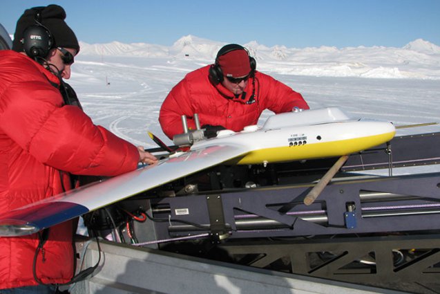
“With drones, we can study melting and other processes as they’re happening, on a very fine scale,” Zappa said. And they can cover hundreds of square miles of ice and ocean with every flight. “They’ll go about halfway to Greenland and back on every flight,” he said. It takes just two people to launch and recover the drones, which take off and land like conventional winged aircraft.
Unlike the high-altitude Global Hawk drones NASA uses to study hurricanes, the unmanned vehicles that Zappa uses, known as Manta UAVs, are modest in size and cost. They run between $100,000 and $250,000, compared with a Global Hawk’s price tag of more than $200 million; they have an 8-foot wingspan compared with the Hawk’s 130 feet; and they carry up to 10 lbs. of scientific instruments vs. the bigger aircraft’s ton and a half.
The drones not only skim just feet above the surface for close-up observations, they’re also designed so the scientists can swap instruments in and out quickly between flights, then send the aircraft back out, like the pit crew at a NASCAR race. One instrument package, for example, uses heat-sensitive, near-infrared cameras to measure variations in temperature in both ice and the water. Another has cameras that detect both infrared and partly visible light, allowing the scientists actually to see the structure of the disintegrating ice. Another carries a radar altimeter, which makes high-precision measurements of the ice’s surface texture. Yet another drops “microbuoys,” which plop into the frigid water to gauge salinity, then beam the data back to base.
While the instruments on these flights are focused on studying changes in sea ice, Zappa said, “the technology is applicable all over the world.” You could go to the equator to look at algal blooms or the day-night cycle of carbon dioxide going into and out of the ocean or dozens of other phenomena, he said.
Ingen kommentarer:
Legg inn en kommentar
Merk: Bare medlemmer av denne bloggen kan legge inn en kommentar.